Saturday, September 27, 2008

The Return of the Camping Bike

Velo Orange Campeur Decals


The idea of bike camping has been creeping into our insular little bicycle culture for some time now, but I confess to being rather dismissive of the trend. Sure, some people go camping by bike. But so much so as to create demand for camping-specific bicycles? Nah, I thought. But seeing the decals on the new Velo Orange "Campeur" model at Interbike earlier this year really brought it home for me: Camping bikes are for real. The now in-progress long term review on the Gypsy by Trade blog has further fueled my curiosity.


Le Campeur

The camping-specific bike is not a new concept. The original French campeurs, popular through the 1940s-1960s, were designed for cyclo-camping - a variation of cyclo-tourisme involving shorter trips and heavier loads. Typically these bikes were built with 650B wheels and wide tires. Front and rear low-rider racks were standards features.


French Fender Day

Frames in larger sizes were often built with supplementary diagonal stays, to prevent flex.


Rivendell Hunqapillar

Today, Rivendell offers several "diagatube" bicycle models based on a similar premise. This is fitting considering that the current popularity of bike camping is in no small part due to Rivendell's promotion of what they call the S24O: the sub-24 hour overnight trip. The idea is that you set off after work, ride to a local camping spot, spend the night there and return in the morning. Whereas full-on bicycle touring requires considerable time commitment, even the busiest of people can manage the S24O. There are now blogs and a flickr group dedicated to the practice.


Rivendell by the River

So what is the relationship between bike camping and a camping-specific bike? In a sense, any bike that can carry camping gear comfortably will be suitable for the job. Beyond that, it mostly depends on the length and terrain of your route. Touring bikes equipped for wide tires, fenders and racks - such as the Surly Long Haul Trucker and a number of Salsa and Rivendell models - have made popular choices. There has also been a trend to convert vintage touring bikes to 650B wheels (for extra tire clearance) and use them in this capacity with the addition of front and rear racks. But a camping bike could also be a transport bike, even a cargo bike or a capable folder for that matter. There is no precise definition.


Velo Orange Camping Bike

So what can we expect from a camping-specfic bicycle model? A number of features come to mind: robust tubing to accommodate the weight of gear, long chainstays for pannier/heel clearance in the rear, eyelets for front and rear racks, clearances for wide tires and fenders, and a reliable braking system. The VO Campeur is additionally interesting in its low-ish trail front end geometry, which some believe to be helpful for carrying a considerable front load.


Will camping bikes take off? The concept of bike camping already has, so it's really a matter of whether the campeur is sufficiently distinct to carve out its own niche. I suspect the concept inspires and attracts a slightly different crowd from those who would go for a standard touring bike, and that's kind of interesting in of itself to observe. Personally, let's just say I am happy to live vicariously through others' bike camping adventures, while traveling light myself. But to the bike campers out there: What is your bicycle of choice, and do you see value in a bike that is optimised for camping?

Thursday, September 25, 2008

Sand Piles that Move

We have had awful wind storms this past week. Here are some of the sand piles that we now have in different places than they were in before. The fence in the first photo used to be 4 feet high, now it is about 3 feet. You can see some dog tracks in the some photos.


Sunday, September 21, 2008

Hairy Beastie


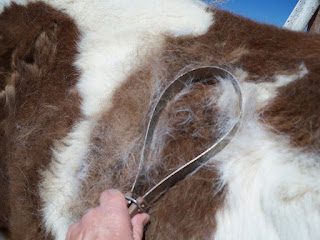
Time to brush the horses. First I did the bay mare, Nita, then on to the old paint, Sunny. But Nita really likes to be brushed and tells me she wants more by shoving her nose in against Sunny. But Sunny is the worst of my Hairy Beasties so he gets the most. The hair comes off in swirls that almost look like big hairy worms. then it is all in a pile at his feet. Hate to say it but I know I will have to do it all over in a day or so.


Thursday, September 18, 2008

Rock Detail - Latourell Falls


Columbia River Gorge, Oregon


I had the urge today to look through some images from the trip out west that I took in and work on a couple of waterfall images from that trip. Latourell Falls was my goal... I had remembered taking some photos of that falls that I really liked but hadn't worked on yet. Of the many waterfalls within the Columbia River Gorge, Latourell is unique among the best-known Columbia gorge waterfalls, in the way that it drops straight down from an overhanging basalt cliff. Most of the falls tumble to some degree, but not Latourell. The thing I found most amazing about this waterfall was the interesting rocks on the cliff face behind the falls.


Three O'Clock Rock Silent Running ..

Steve and I made our second weekly trip to Darrington to Three O' Clock Rock. This time to climb Silent Running (II, 5.10a/b.) We got there a bit earlier this time and welcomed the cooler temps.

Now, prepared with watches we were able to make the hike to the base in 30 minutes. (It also only took us 1.5 hours from Steve's house to the trail head.) After reaching the base we started gearing up. Then Steve led out on the first pitch. This was agreed on earlier to give Steve the lead on the final crux pitch which he had not previously climbed.

The first pitch was nearly a rope length of easy climbing. (Almost running up the slab.) Steve brought me up and it was time for the second pitch where the difficulty increased significantly. Well, at least you had to be weary of where you put your feet, and there was no more running. I led the second pitch on some nice friction moves where it got harder through the last two bolts to the belay. I arrived at a nice belay ledge, and brought Steve up.

Steve got the lead on the next 5.9 pitch which started out with what looked to be great rock. However, it was polished and slippery. Foot placements were critical through the first four bolts or so. Then the route moved right a bit and the traction was phenomenal. Completely different character for the second part of the pitch. I followed him up and was off on to the next pitch.

From this pitch on, the first bolt was often a bit off the belay. (In this case, about 10-12'.) After clipping a few bolts, I could no longer see any above me and in a shaky stance decided to look at the topo. In the difficult stance for viewing, I accidentally looked at the following pitch which moves right after a few bolts. Since I could not see any bolts, I started to move right where people had clearly been before. After I moved right, I was stuck out on a ledge and could see the "next" bolt up and to my left about 15' or so. (There was a hidden piton that I could not see about 10' above the last point I was on route.) So I yelled to Steve about getting back on route. I put a cam in a weak flake and decided to head straight up to a ledge system that would bring me to the last bolt on the pitch. The climbing was easy up to the ledges, but was unprotectable. After going up about 20' I put another cam in a flake, and started leftward on the ledge system to get back on route. After crossing the ledge, I used some quartz dikes to gain the bolt and return to the pitch. The final climbing of the pitch went up a fun small gear protectable lie back past a bush to the anchor. Once at the anchor, I could see where I went wrong. Steve pointed out to me the piton as he made his way up my off route excursion.

Steve led off on the next pitch which was more of the same to start with, then some climbing up some creaky flakes to get to the anchors.

The penultimate pitch is where the fun really started. I led off up and over an overlap and mostly easy terrain while moving leftward. Then the the slab steepens. There is a section of steeper slab with widely spaced (10+') bolts going up. The bolts are closer to the left of this narrow slab near an inviting grassy corner. When I first arrived at the steeper section, it looked as though the right hand side would also work, but reaching the bolts may have been difficult. So I followed the bolt line up friction moves to another overlap and a piton. I clipped the piton and worked my way over the final overlap to the anchor, a hanging belay. I brought Steve up to my position and we readied the rack for the next pitch. (The guidebook stated gear to 4" for the final pitch, so we pulled out the 3 & 4" cams, but Steve didn't need them.)

Steve left the belay to clip the first bolt on the final pitch. There were a few moves on a slab protected by a bolt before having to surmount a double overlap. The first overlap was not as high, and was protected by a bolt. The second was stepped, and higher and needed to be traditionally protected. Steve made his way through the overlaps and I asked him if he felt they were the .10b portions. He didn't think so. He continued up onto a slab where he took on a bolt before reaching the final flake. He told me his feet had had enough and he needed a rest. After resting on the rope briefly, he made the easy moves to the flake and was shortly at the belay. I found the moves through the overlaps to be difficult and required me to bounce to make the moves. They were high steps and required manteling as there were no holds above the overlaps. Once past the overlaps, I used any possible rests before gaining the slab that tired out Steve's feet. I moved up the slab quickly and deliberately. I was soon at the fun flake moves to finish the route. Once there, we set up our rappel and started rapping the route.

The rappels were uneventful, except for a serious lapse in judgement on my part where we reached one of the larger rap ledges and I forgot to clip in before undoing my rappel. That will never happen again! Yipe.

I liked this route better than Total Soul from last week. I think the line was more logical and the final two pitches were really 3 star. (Maybe four.) At times Silent Running seemed more run out than Total Soul, but it was usually on easier ground. It is a slightly shorter and easier route, so it is a little quicker to finish than Total Soul if you have less daylight to work with. It was more enjoyable too, because last week's "warm up" on Total Soul made the moves on Silent Running pretty familiar to me and it feels like I may have gotten rid of the rust from not climbing for a while.

On the way down (rapping and the drive out) we discussed with each other that it seemed darker than the previous week. We knew we were getting out a little earlier and there were no clouds in the sky. We couldn't understand why. I thought maybe because it was so hot the previous week, that being in the shade did not make a difference. It wasn't until we got back into Darrington that we had our answer. There was a fire on the other side of Whitehorse Mountain. We had seen the forest service helicopter in the morning at a makeshift helipad near highway 530. (But there were no signs of smoke in the morning.) We stopped to see it landing and it appears there were fire fighters from Targhee NF on the scene. After snapping a few pics, we drove home.

Fire on the Mountain

My pics are here.

Wednesday, September 17, 2008

Small Horse


This is one of my smallest horses in my collection. This colt is only about 1 inch tall and is china. I have 3 blue horses on a wheel that came out of a cracker Jacks box that are only about 1/4 of an inch tall each that are the smallest I have. I couldn't locate them for this photo shot.

Custer State Park :: Nature's Bounty

Friday, August 26th - - I took my time driving through the park as I was leaving, making a big loop north and another one toward the south.


The Cathedral Spires are in the northwest side of the park, along Needles Highway, and were magnificent in the early morning light.


The Iron Mountain Road takes you along the north east side of the park and was considered an engineering marvel when it was first built. It is still rather impressive with the sharp curves, hairpin turns, wooden bridges, and tunnels that were bored through the granite rock – the three tunnels on this route perfectly frame the Presidents on Mount Rushmore that are seen in the distance. I took no pictures on that route – there was too much traffic and the parking areas near the tunnels were filled to capacity when I passed by that way yesterday.


I only drove a short portion of the Wildlife Loop Road as I was leaving the park - it went back north and I was headed south. Buffalo were grazing in the meadow when I turned onto the road.


A hungry calf.


Upon exiting the road on my return, the Bison were taking a break in the meadow. The park maintains a herd of about 1,300 bison, of which these were but a small part.


These antelope were seen a little ways south of Custer State Park but before getting to Wind Cave National Park. I stopped at Wind Cave visitor center but did not take a tour into the cave – too many steps down and I've toured several other large caves.


Monday, September 15, 2008

Musical flowers


Bigleaf Snowbell, Styrax grandifolius

We encountered this beautiful shrub on a wildflower rescue. It's a tricky area. On one hand, it's very near a creek so houses are probably not going to be built directly on top of it. On the other hand, (1) you never know, and (2) high amounts of soil runoff might kill everything here anyway. So we are just taking some of the plants.


The shrub was near this little stream. The water goes underground around the middle of the picture, and reemerges just out of the shot on the right.


I'm 98% certain that this is Bradbury's Bergamot, Monarda bradburiana. (It's not in flower yet, so I can't be 100% sure.)

A few more shots of the Bigleaf Snowbell:


Gorgeous! I got such a charge when I first spotted this plant. ("Come look! What is it, what is it, what is it?!")

The flowers look as though they should be wonderfully fragrant... they had a light scent but I wouldn't exactly call it pleasant.


A similar shrub is American Snowbell (Styrax americanus). That plant has smaller leaves and fewer flowers per raceme.

Saturday, September 13, 2008

Veterans in the Family


Grandpa - Rolland Victor Phend - WWI

1917-1919

saw duty in France, was gassed

photo taken in June 1983


Dad - Jack William Wiseman - WWII

1943 - 1946

saw duty in the Pacific arena with the 511th


Brother - Charles Douglas Wiseman

1964-1968

Hospital Corpsman, served with the Marines at Camp Lejeune


Brother - Jack Lynn Wiseman

1969-1973

Hospital Corpsman, served with the Marines in San Diego


me - Becky Wiseman

1969-1979

Photographers Mate, numerous duty stations


You can read more about the military service of ancestors and others in my family in this post from ...


Tuesday, September 9, 2008

Trail running with nature in the Laurel Highlands

Here we are it's already August. Hopefully this blog post won't be my longest...

I've run some miles and enjoyed hikers' smiles...

The highlight of my week was a venomous treat!

Here's it is with fangs that are hollow. After this photo my post will follow...


Another "local" trail lover from the Laurel Highlands


Since my last post I've put in a few days. The running I've done has been training efforts to get ready for a 5K coming up next weekend and anattempt at completing a LHHT double (140 miles) this fall or at the latest next spring. I've been doing a little speed conditioning for the Laurel Hill 5k (my only "race" this year) as well as some quality trail time with my son (now that he's home for a couple of days). Training for both efforts doesn't seem to be meshing well. My trail legs can barely turn over the necessary amount to produce even a 6:45/mi. 5k. I'd like to do well in my one and only race this year, although I highly doubt I will. The cool thing is that it's a mellow road race (through the woods). The proceeds help support the park which in turn indirectly helps the LHHT.


RECENT TRAINING:


8/2/13 Mt. Pleasant Coal and Coke Trail

Basic tempo run on a local rail trail that seems to be growing in popularity. It's not the most scenic, but does contain nice habitat which usually provides me with some good birding while running. 10k in 44:40


8/4/13 Laurel Highlands Hiking Trail (LHHT)SOBO

It was Saturday night and the weather for Sunday was predicted to be amazing. Mid 70°'s with a 10% chance of rain. It would be perfect day for a long run. I was feeling the "after burn" in my quads from that tempo run on Friday, but couldn't resist these prime conditions. Laura mentioned that Sunday would be a rest/non running day for her and I kindly asked if she would mind supporting me for a long point to point run. She said she'd be happy to help and we set off to prepping and planning.


Laura writing the itineraryand helping me pack


Trail Love - typical drop can containing a couple hours or more of fueling


My last long run was northbound, commonly calledNOBOin trail lingo. Last week I ran from Ohiopyle to Hickory Flats Road (38 miles), stopping due to bruising on the ball of my left foot. This time we would switch it up. Laura would drop me off in Seward at the northern terminus of the LHHT and I would run in a southbound direction or SOBO. We've found running the trail in this direction makes it easier to crew one another. We usually put drops of food and water at Rt. 271 (highway not parking lot) on the way up and another at Rt. 30 while the crew person is on the way home to kill about 6 hours. This prevents having to meet the runner until over half way at (39miles) Rt. 31 parking lot. The distance from the main trail to the parking area is very short and favorable to meet crew and resupply. From there we take it as it goes. I'll get into that shortly.


The alarm went off at 4:15AM. We were basically packed and ready to hit the road. I pressed some kick ass coffee for the road while Laura made PB&J's for the drop cans and out the door we went. We placed the Rt. 271 resupply and headed to the trail head in Seward. On the drive over we were treated to star filled skies and a crescent moon just as the forecast predicted. We were there by 5:45AM. Just enough time for a 6:00 start. I quickly got ready and received a loving send-off at 6:00 sharp.


Putting on my headlamp for the start


A few minutes to start


Its GO time, out like a bullet slug ;)


I was definitely feeling the tightness in my legs for the first couple miles. My tempo workout wasn't the best prelude to a long or possible thru-run. I wasn't feeling optomisitc or fast out of the gate and figured I'd at least get in a 50k training run on a beautiful day. I ran/hiked a couple sub 12's up the intial climb. I stopped at the power line crossing to snap this quick photo.


The power line crossing out of Seward on the LHHT


Shortly after my photo, the brief glimpses of sky through the canopy in the Northwest looked ominous. Where was my sunshine filled happy morning? 10% chance of rain? By the gravel road at mile 6 it was bucketing rain. What's worse than the gravel road section of the LHHT? Running it in a cold, hard, rain... For two hours it rained. Thankfully mother nature provided plenty of wet weather training last month and I was well prepared for the soaking I received. Here's the radar image that Laura texted me not long before the rain started. The only storm around and it was on track with me!


Laura's image and text. "Sorry, hope you stay dry"


Looking up at the Ridge from the West near Rt. 30, photo L. Hahn


Thankfully I ran out of rain somewhere between Rt. 271 and Rt. 30. Both resupplies went well. Both stops combined cost me about 7min. I ate PB &J's from drops while I ran. Each drop can contained a handful of M&M's, a PB&J sandwich in foil (I find the foil acts as a "plate" while eating and running), gels, and Elete rehydration tablets.


Rt. 30 drop in place thanks to Laura

When eating solid foods while running I try to adopt the same practices as when eating a gel on the run. Small bites over a mile or two, sipping water to help wash it down. I was making good time and right on track with my estimations despite resupply stops and 1 call to nature. Hydration was going great. I was urinating regularly and clearly. I was averaging one handheld (21oz.) of Gatorade per hour supplemented by plain water and Elete Tablytes, and a gel (GU,Cliff, etc.) both at about 1tab and gel per hour).


I still smile every time I cross the NEW turnpike bridge.

During the 15 miles from Rt. 30 to 31 I started to bonk from dehydration and not enough calories. I realized and started the process of hydrating and fueling. I was well on my way to better pulling into Rt. 31 trail head to meet Laura for the first time of the day. I was still on schedule, but noticed a slight pain on the top of my foot. I believe this was due to an overtightned shoe lace while sliding around in the rain. Aware but not overly concerned, I loosened my lace areas affecting the sore spot to minimize the pressure and further issues. My break at 31 with Laura wasmuchlonger than my 4 minutes at the Rt. 271 and 3 minutes at Rt. 30 drop. I basically stopped and had a picnic. I just want to point out that this is why training runs are so much cooler than high dollar races! No crowds, no pressure, just pure fun and running for the love of it.


Mid run picnic anyone?


Laura ready anxiously waiting to run with me

It was delicious. I ate a ham and chese sandwich, baked potato, a few pretzels, anddrank some chocolate milk and coffee. This was no ordinary aid break. We're talking an hour or so ;) After our picnic, Laura joined me in running about 3 miles before saying goodbye and turning back towards 31. Her next stop would be Rt. 653 trail head. We met there and I picked up a refill on supplies and my headlamp ate some more and hung out longer than normal.


Rt. 653 trail head, a happy trail runner

By this point I was far off my schedule for the time of day, but still on pace as far as speed of travel goes. My foot was getting worse, but It still didn't seem enough to stop and I was enjoying the run. My legs were hanging tough and were feeling great. I took off from Rt.653 trail head and was running smooth. The sun was setting near Cranberry Glade and the lake was like glass. I decided to stop for a photo and to put on my headlamp.


Cranberry Glade at sunset


The rest of the run to Maple Summit Road crossing went well and I met Laura sitting in the dark. By this time the bruising had become enough to call my training run done. I love running in the dark and Maple Summit Road to Ohiopyle SOBO might be my favorite section of the entire trail. A bit of a bummer, but not worth the risk of ruining my training. I need to remember I've only been back running for a short period of time. The run went well and I had the best conditions and support for a 60 mile trainer.


The End

Distance: 60 miles

Run Time (without picnic): 12:36

Pace: 12:36/mi.

Elevation gain 5,000', loss 3,800'


8/6/13Laurel Summit State Park,Wolf Rocks trail loop

Went for a 4.5 mile run with Laura. My instep was still sore from my 60 miler, but the day was beautiful and I couldn't pass up a run with my Sweetie. I laced and tied my shoes very loose for this easy run. A fun run out to the overlook and back on the loop. Lots of mountain bikes out enjoying the weather as well.


Distance: 4.5 miles

Duration:50:55

Pace 11:19/mi.

Elevation - not much


8/7/13 Iwent for a 5.5 mile hike with my son Skyler and we were fortunate enough to see these beauties along the way.


Yellow Phase Timer Rattlesnake


Black Phase Timber Rattlesnake


Someone is seriously excited to see some Rattlers
especially the one behind him... Can you find it?


8/9/13LHHT Route 31 NOBO with Granola the trail dog

I set off yesterday to get in a couple hours running on the trail. I decided it would be a good day to take our trail dog "Granola". He was excited to go and we drove to Rt. 31 trail head. The skies were dismal, but we set off at a decent 9:00/mile pace and only made it out about 2 miles before the rains hit. Once again I found myself plodding along through a downpour, this time with my dog in tow. The trail quickly turned into a stream and in many low areas the water/mud was so deep Granola would bottom in swamp water up to this torso. We kept going a few more miles until enough was enough. We turned around about 3.5 miles out and continued our efforts back to the car. Granola was getting a little tired on the way back, so we slowed pace a little, but still made good time considering trail conditions. He assured me he had a blast once back at the car. We toweled off and made our way home to dry out!


Distance: 8 miles

Duration: 1:10

Pace: 8:45/mi


Help... I've about drowned in a river that didn't exist an hour ago!


The road to 31 trail head after the storm was ending...


8/10/13LHHT Route 653 NOBO

Spent another glorious day our hiking with my son Skyler. We decided to hike north from 653 trail head out to Middlefork overlook. The weather was perfect and we enjoyed a nice relaxing walk out to the overlook, hung out a few minutes and hiked back to the car. Awesome hike with one of my favorite hiking partners.


Distance: 5.4 miles

Duration: 1:35:53

Pace: 17:33/mi.


Littleman at Middlefork over look