The morning of Sunday, December 27, .. was another chilly, gray, gloomy, overcast morning; the same as the three previous mornings. I had been hoping for at least a little sunshine and a slightly warmer day but, based on its beginnings, I didn't think that was going to happen. Saturday I had gone to St. Marys to check out the town and find out about the ferry going to Cumberland Island National Seashore. Good thing I did, as reservations are recommended!
So the reservations were made, but not paid. I could still decide not to go. However, I figured with the way the weather had been, it was as good a day as any!
After a short drive into St. Marys, then paying the fees ($17 for the ferry and $8 for the National Park Entrance, the latter was covered by my wonderful National Parks Pass), and listening to a short orientation lecture, I boarded the ferry with the other passengers. I was amazed by the number of people with camping gear, it seemed like about half the people on-board were campers. The campsites on the island are primitive. The only facilities available are showers and restrooms and those only in the main campground areas. You're completely on your own in the backcountry. Whether they are staying in the campground or backcountry, everything that is needed by the camper has to be brought in by them and anything they bring in has to leave with them. I'm not quite prepared, yet, for that kind of camping, especially when the temperatures dip down below the 30s overnight!
There was a heated cabin area on the ferry where some passengers sat during the 45 minute ride out to the island but many, myself included, opted to sit outside in the cool morning air. Refreshing is how some might have described it. Most of the day-trippers like myself disembarked at the Dungeness Dock on the south end of the island while the rest went on to the Sea Camp Dock a mile to the north, where it was a short trek to the campground.
In order to learn a little about the history of the island and its inhabitants, I opted to take the Ranger Guided Tour of the Dungeness Trail. I've since found several websites that give more detailed information and they have added considerably to what I learned that day. Links to those websites will be listed at the end of this post. The Ranger who gave the tour was very knowledgeable and entertaining as well.
The Dungeness Trail leads you to the Dungeness Mansion, or rather, to the ruins of the second Dungeness Mansion. The first Mansion, four-stories high and huge, was begun in 1796 by the widow of Revolutionary War General Nathanael Greene and her second husband, Phineas Miller. The mansion was completed in 1803. Shortly thereafter Dungeness became a mecca for the early Georgian high society. After the Civil War the Mansion was not maintained. It fell into disrepair and in 1866 burned to the ground.
About 1880-81 Thomas Carnegie (a brother and partner of Andrew Carnegie) purchased much of Cumberland Island. With his wife, Lucy, Thomas built the second Dungeness Mansion where the first had been. It was a 59 room Scottish-style castle complete with turrets, a pool house, 40 outbuildings, a golf course, and acres of manicured gardens. Thomas Carnegie died in 1886 leaving his wife Lucy with nine children. Over the years, four other mansions were built further north on the Island for use by the children. The house at Plum Orchard has been restored and is open for tours twice a month. It happened to be open the day I was there but I chose to explore the southern end of the Island rather than view the house.
The second Dungeness was used through 1929 then it sat vacant for 30 years. In 1959, it too burned to the ground. All that remains of that magnificent mansion are a few walls, standing like sentinels, guarding the past. Some day, they too will fall.

Left side of the Dungeness Ruins, from the front.

Dungeness Ruins from the front-left corner.

Dungeness Ruins from the rear-left corner.

Dungeness Ruins. Window detail.

The remains of the recreation building.

The Tabby house, which stands off to the right side of the Dungeness Ruins is the oldest house on the Island. Tabby is a kind of concrete made of oyster shells, lime and sand. Built around 1800, it dates from the time of the first Dungeness Mansion. It was the only building in the area that was spared by the Carnegie's when they built the second Dungeness.
To be continued...
See these websites for more information on the history of Cumberland Island and the National Seashore:
- National Park Service
- Outdoor Places
- CNN Article (Posted in 1998, but still valid.)
- Wikipedia
 The Park remains closed until further notice. For updated information, call 360 569 2211 ext 9.
 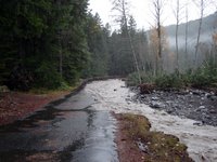 Aside from the rage of the Nisqually River, Longmire is a relatively quiet place. The NPS has closed its offices, and only essential personnel are allowed in through a backroad (which is largely washed out and requires shuttles). See image above, taken near the Eagle Peak Trailhead...
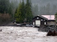 Longmire is isolated by washouts and mudflows, so it feels like a safe little island. Well, "safe" unless you're in the Emergency Operations Center (pictured left) which is being undermined by the Nisqually River... Oh, and some of the electrical and water systems are also damaged, but most of the facilities will probably survive the storm.
 What do you get when you combine an unsatiable hunger for ski and snowboard "
 Slush Cup was a lively event once again - those folks throw quite a party! Participants almost equaled their spectators, and even the climbers perched atop Castle Peak enjoyed the entertainment, as the costumed skiers and boarders skimmed across the tarn at the base of Pinnacle. Afterwards, the crowd gathered at Reflection Lakes for a tailgate party, feeding skiers and hungry tourists alike.

 Looking west toward the window. 11:11 am.
 Casa Grande. 11:17 a.m.
 Creepy tree with Casa Grande in the background.
 What do you do if it is too cold to just sit around the picnic table and you don't want to go for a hike? You go for a drive, to lower elevations and hopefully some sunshine.
 About halfway down the mountains. 3:11 pm.
 The Chisos Mountains, from the northwest side. 4:00 pm.
 The Chisos Mountains, from the east side. 5:16 pm.
 Casa Grande. 5:57 pm.
 The only trace left of the snow in the evening was in the trees in the high elevations.